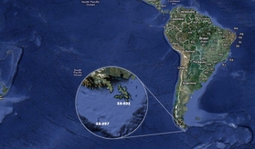
Wollaston (SA-031) & Diego Ramirez (SA-097)

The waters around the Cape are particularly hazardous, owing to strong winds, large waves, strong currents and icebergs; these dangers have made it notorious as a sailors’ graveyard. The terrain is entirely treeless, although quite lush due to the frequent precipitation. Winds were reported to average 30 km/h (19 mph), with squalls of over 100 km/h (62 mph) occurring in all seasons. Diego Ramirez is 106 km south-west of it, in the Drake Passage. Temperature in January-February ranges from highs of 14°C (57°F) to lows of 5°C (42°F). Snowfall can occur in the summer anywhere south of the Beagle Channel. The cold and wet summers help preserve glaciers. In summer, the wind at Cape Horn is gale force up to 5% of the time, with generally good visibility. Greatest rainfall is in March, 137.4 mm, while the least is in October, 93.7 mm.
The Strait of Magellan, Beagle Channel, and all other passage between the islands that are part of the Wollaston and Hermite groups are notorious for treacherous williwaw winds, which can strike a vessel with little or no warning; given the narrowness of these routes, there is a significant risk of then being driven onto the rocks. Several factors combine to make the passage around Cape Horn one of the most hazardous shipping routes in the world: the fierce sailing conditions prevalent in the Southern Ocean generally; the geography of the passage south of the Horn; and the extreme southern latitude of the Horn, at 56°S.
The prevailing winds in latitudes below 40°S can blow from west to east around the world almost uninterrupted by land, giving rise to the “roaring forties” and the even more wild “furious fifties” and “screaming sixties”. These winds are hazardous enough in themselves that ships traveling east would tend to stay in the northern part of the forties; however, sailing to Cape Horn requires ships to press south to 56°S, well into the zone of fiercest winds. These winds are further exacerbated at the Horn by the funneling effect of the Andes and the Antarctic Peninsula, which channel the winds into the relatively narrow Drake Passage.
The strong winds of the Southern Ocean give rise to correspondingly large waves; these waves can attain enormous size as they roll around the Southern Ocean, free of any interruption from land. At the Horn, however, these waves encounter an area of shallow water to the south of the Horn, which has the effect of making the waves shorter and steeper, greatly increasing the hazard to ships. If the strong eastward current through the Drake Passage encounters an opposing east wind, this can have the effect of further building up the waves. In addition to these “normal” waves, the area west of the Horn is particularly notorious for rogue waves, which can attain heights of up to 30 m (100 ft).
Ice is a hazard to sailors venturing far below 40°S. Although the ice limit dips south around the Horn, icebergs are a significant hazard for vessels in the area. In the South Pacific, during the summer in Southern Hemisphere, icebergs are generally confined to below 50°S. However, the Horn remains below the latitude of the iceberg limit. These hazards have made the Horn notorious as perhaps the most dangerous ship passage in the world; many ships were wrecked, and many sailors died, attempting to round the Cape.
At the time it was discovered, on 25 January 1616, the Horn was believed to be the southernmost point of Tierra del Fuego; the unpredictable violence of weather and sea conditions in the Drake Passage made exploration difficult, and it was only in 1624 that the Horn was discovered to be an island. It is a telling testament to the difficulty of conditions there that Antarctica, only 650 km (400 mi) away across the Drake Passage, was discovered as recently as 1820, despite the passage having been used as a major shipping route for 200 years.
